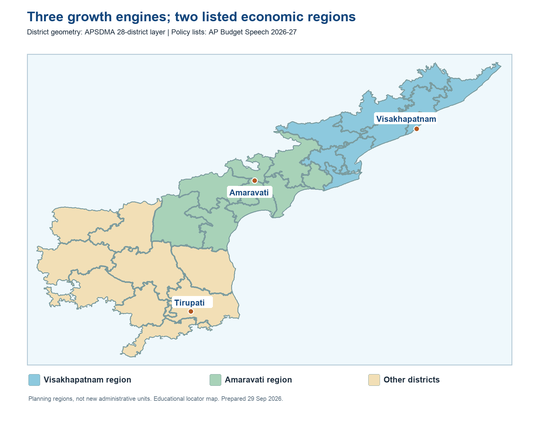
The 2026-27 Finance Minister's speech describes Visakhapatnam, Amaravati and Tirupati as regional growth engines. The speech names a Visakhapatnam Economic Region running through the north and Godavari side, and an Amaravati Economic Region covering much of the central belt. A Rayalaseema horticulture plan spans dryland districts and adjoining project areas. These are policy planning regions, not replacements for revenue districts or police jurisdictions. Study them on the current 28-district map so an old 26-district atlas does not conceal Markapuram and Polavaram.
In the northeast, hill terrain, north-coast agriculture, Visakhapatnam's urban industry and port services create very different opportunities. In the centre, the Godavari and Krishna systems support intensive cultivation, aquaculture, processing, transport and urban markets. The southern coast combines ports, industry, agriculture and the Sriharikota-adjacent space economy. The western and southern interior faces greater water stress and puts a premium on horticulture, micro-irrigation, storage and road access.
Regional policy is often announced before all projects are funded, built or operational. The speech's proposal amount for a region is not the same as a budget allocation or money spent. For active recall, name one input, one bottleneck and one market connection for each region. This gives more durable understanding than memorizing slogans or unverified project status.
Worked example: On the current district map, mark Visakhapatnam, Amaravati and Tirupati as urban anchors. Then draw the northern port and industry belt, the central administrative and services belt, and southern tourism and horticulture connections. These are planning relationships, not newly notified districts. If a chart compares an old 26-district survey with a 28-district map, identify the two newly created districts before interpreting any regional ranking.
Active recall: Locate the three proposed growth engines and explain why a regional plan is not an administrative district.
AP economic regions on the current 28-district boundary map
The blue and teal areas follow the district lists in the 2026-27 budget speech. Southern and other districts are a study grouping, not a formally notified third boundary.
Read this visual
The colours show planning groupings on present-day district polygons. They do not turn the Visakhapatnam or Amaravati economic region into a new administrative unit. Compare the map with the budget speech's district list, and keep the older survey's statistical boundaries separate.
Map geometry: APSDMA. Budget figures and region descriptions: AP Finance Department. Educational comparison visual.