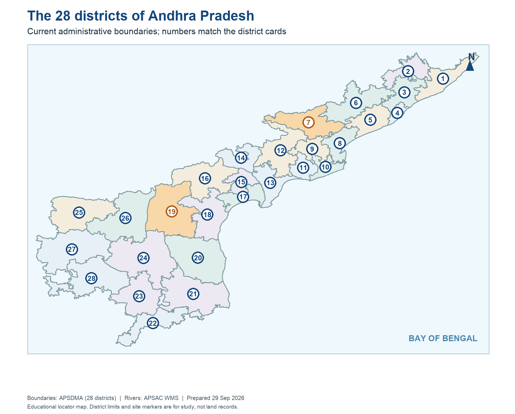
Administrative maps change. Andhra Pradesh's 2022 district reorganisation created a 26-district framework from the earlier 13-district arrangement, and later changes took the current count to 28. A map used for a 2011 census table, a 2024 welfare release or a 2026 administrative office should therefore carry its date. Polavaram and Markapuram are the two newer district names in the current map used here. Do not shift old district totals into new outlines without lower-level reaggregation.
The numbered plate in this volume teaches present district locations, not the location of every office or the boundary history of each mandal. To determine which Collector, RDO, Tahsildar or ZPP handled a case on an earlier date, read the creation notification and transition rules. In an exam, the question's time phrase is part of the answer. If a source still says 26 districts, it may be historically correct for its data period rather than factually wrong.
Worked example: A government project document names an old parent district while the current map shows a newly notified district. Both can be correct for their dates. Use the project document's publication date for historical administration and the new Gazette for current offices. A police exam question may deliberately ask 'as of 2022' or 'currently'; underlining the date avoids an otherwise easy error.
Active recall: Give the 13, 26 and 28 counts with their appropriate periods. Why must a district-level time series be reworked after boundary change?
AP's current 28-district map
Numbered boundaries are from APSDMA; office changes require dated orders.
Read this visual
The numbered polygons are the current district arrangement. Historical maps with 13 or 26 districts remain valid for their own dates. For a boundary-sensitive legal question, check the Gazette and office transition order rather than relying on the map alone.
Current district geometry: APSDMA. Legal structure: official Constitution, India Code and AP administrative sources.
28 district map key
01 Srikakulam | 15 Guntur |
02 Parvathipuram Manyam | 16 Palnadu |
03 Vizianagaram | 17 Bapatla |
04 Visakhapatnam | 18 Prakasam |
05 Anakapalli | 19 Markapuram |
06 Alluri Sitharama Raju | 20 Sri Potti Sriramulu Nellore |
07 Polavaram | 21 Tirupati |
08 Kakinada | 22 Chittoor |
09 East Godavari | 23 Annamayya |
10 Dr B R Ambedkar Konaseema | 24 YSR Kadapa |
11 West Godavari | 25 Kurnool |
12 Eluru | 26 Nandyal |
13 Krishna | 27 Anantapuramu |
14 NTR | 28 Sri Sathya Sai |